Skip to content

Lanzo d'Intelvi

Sighignola Belvedere

Visit duration
30 min – 1 h
Booking
Not required
Area
Val d'Intelvi
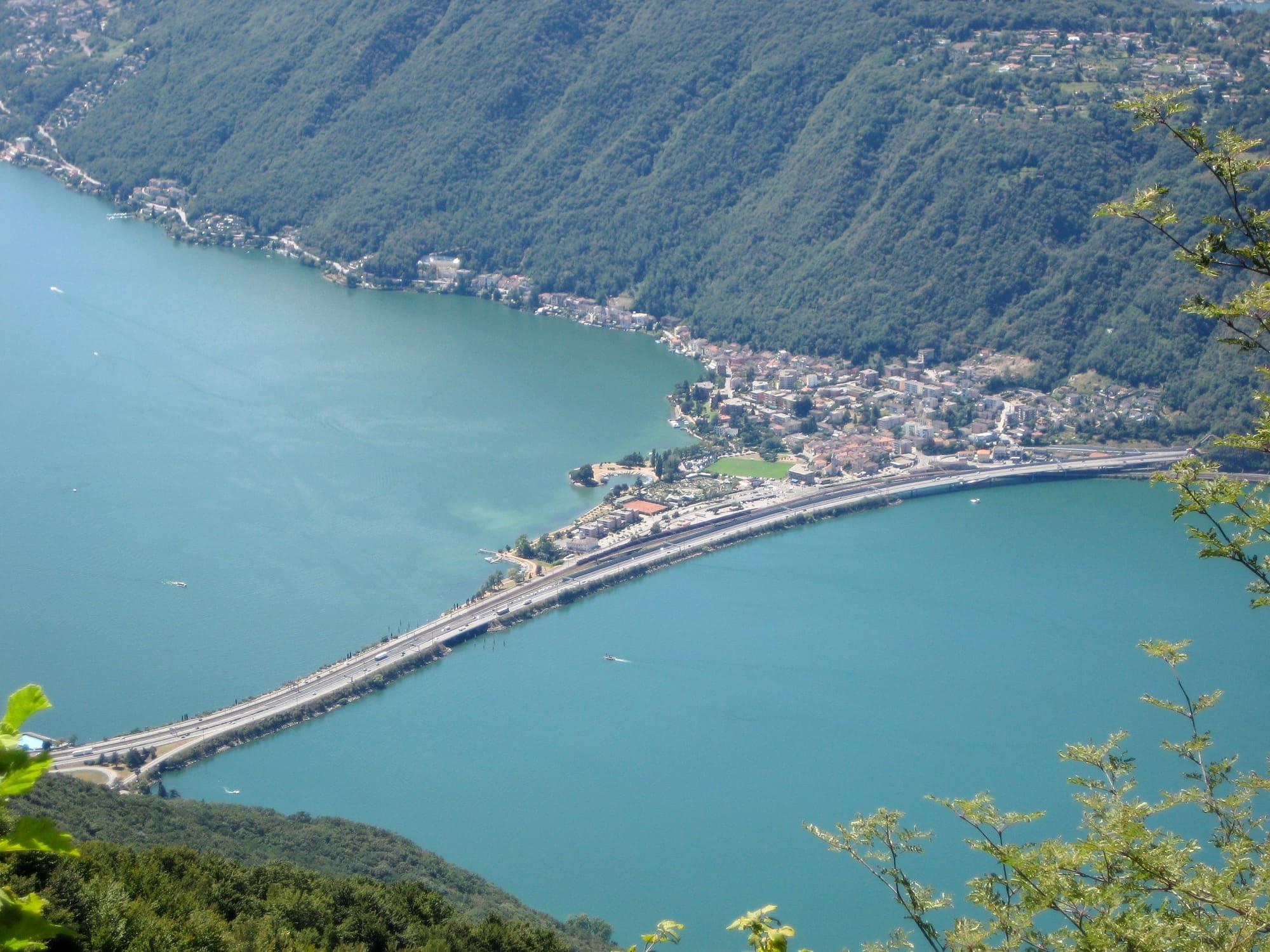
The Melide causeway crossing Lake Lugano, seen from high on the Sighignola.Aconcagua · CC BY-SA 3.0
  • Pasquale Relvini · CC BY-SA 4.0
  • Kaitu · CC BY-SA 4.0

1 / 3

The Melide causeway crossing Lake Lugano, seen from high on the Sighignola.

Aconcagua · CC BY-SA 3.0

Why go

The viewpoint is a terrace above Lanzo d'Intelvi, at 1,302 metres above sea level, dropping sheer to Lake Lugano, right on the Swiss border: the summit is in Italy, while the border runs along the terrace.

The road and the viewpoint were opened in 1913 on the initiative of the Touring Club Italiano. In the late 1960s work began on a cable car that was to climb here from Campione d'Italia, but it was never finished; the unfinished upper station on the Swiss side was demolished, and in 2012 a second terrace was opened in its place. On clear days you see the Alpine chain from Monte Rosa to the Bernina, with the Matterhorn. You reach it by car, and on summer evenings it is a place to watch the sunset.

  • The view of the Alps, from Monte Rosa to the Bernina, half an hour from Lake Como.
  • The two terraces on the Italian–Swiss border, one built on the foundations of the unfinished cable car station.

Highlights

  • The view over Lugano
  • Sunset over the Alps

Getting there

  • By car from Lanzo d'Intelvi, on a narrow mountain road.

Practical information

Access

Mountain road that can close for snow or ice in winter

Facilities

Car park 186 m away · free

Distances from the point on the map.

The light

It faces west and stands high: sunset lasts longer here than on the lake, and the blue hour over the Ceresio is long. By car, and with a jacket even in July.

Faces
west
Best light
sunset
Full moon
Tue 24 Nov · 17:06 · north-east
JuneDecember
10°20°08:5616:34ESW
The skyline measured every two degrees out to twenty-two kilometres, and to two hundred where the near mountains let the Alps show. The solid line is the sun's arc at the summer solstice, which leaves the top of the frame; the dashed one is the winter solstice, with the hour it comes out from behind the mountain and the hour it goes back.

See from here where the sun goes, in 3D

All the photo spots

Updated 22 October 2026

The mountains from here

The highest summit in view from here is Monte Rosa, Dufourspitze, 4634 m, 87 kilometres away.

Open the panorama with the summits by name
Cima della Piancaccia, 1611 m, 4.1 kmCima della Piancaccia1611Monte Baraghetto, 1694 m, 4.5 kmMonte Baraghetto1694Cima di Sassalto, 1614 m, 4.9 kmCima di Sassalto1614Montcucch, 409 m, 22.5 kmMontcucch409 · 23 kmColle di Sant`Ambrogio, 533 m, 15.1 kmColle di Sant`Ambrogio533Monte Morone, 497 m, 19.6 kmMonte Morone497Monte San Giorgio, 1097 m, 6.9 kmMonte San Giorgio1097Monte Orsa, 998 m, 10.8 kmMonte Orsa998Monte Crocino, 690 m, 15.4 kmMonte Crocino690Monte San Bernardo, 1020 m, 14.6 kmMonte San Bernardo1020Punta Rognosa, 3282 m, 196.7 kmPunta Rognosa3282 · 197 kmPointe de Charbonnel, 3752 m, 168.2 kmPointe de Charbonnel3752 · 168 kmGran Paradiso, 4061 m, 142.6 kmGran Paradiso4061 · 143 kmCorno Bianco, 3320 m, 87.6 kmCorno Bianco3320 · 88 kmMonte Rosa, Dufourspitze, 4634 m, 87.1 kmMonte Rosa4634 · 87 kmStrahlhorn, 4190 m, 84.5 kmStrahlhorn4190 · 85 kmDom, 4545 m, 88.8 kmDom4545 · 89 kmLagginhorn, 4010 m, 79.3 kmLagginhorn4010 · 79 kmBreithorn, 3438 m, 76.4 kmBreithorn3438 · 76 kmBietschhorn, 3934 m, 100.1 kmBietschhorn3934 · 100 kmAletschhorn, 4195 m, 95 kmAletschhorn4195 · 95 kmFinsteraarhorn, 4274 m, 92.2 kmFinsteraarhorn4274 · 92 kmMonte Gradiccioli, 1936 m, 16.2 kmMonte Gradiccioli1936Monte Zucchero, 2736 m, 48 kmMonte Zucchero2736 · 48 kmPizzo Campo Tencia, 3071 m, 55.3 kmPizzo Campo Tencia3071 · 55 kmPizzo Vogorno, 2442 m, 31.2 kmPizzo Vogorno2442 · 31 kmCima dell'Uomo, 2389 m, 29.8 kmCima dell'Uomo2389 · 30 kmPiz Vial, 3168 m, 73.9 kmPiz Vial3168 · 74 kmAdula - Rheinwaldhorn, 3402 m, 58.6 kmAdula - Rheinwaldhorn3402 · 59 kmTorent Alto, 2948 m, 42.2 kmTorent Alto2948 · 42 kmCamoghè, 2228 m, 19.4 kmCamoghè2228Cima del Vallone, 2135 m, 18.7 kmCima del Vallone2135Cima Verta, 2078 m, 21.1 kmCima Verta2078Pizzo di Gino, 2245 m, 20.9 kmPizzo di Gino2245Mot Rasia, 2123 m, 21.5 kmMot Rasia2123Monte Marnotto, 2088 m, 22.2 kmMonte Marnotto2088 · 22 kmESESSWWNWNNEE
  • Adula - Rheinwaldhorn, 3402 m, 59 km
  • Torent Alto, 2948 m, 42 km
  • Camoghè, 2228 m, 19 km
  • Cima del Vallone, 2135 m, 19 km
  • Cima Verta, 2078 m, 21 km
  • Pizzo di Gino, 2245 m, 21 km
  • Mot Rasia, 2123 m, 22 km
  • Monte Marnotto, 2088 m, 22 km
  • Cima della Piancaccia, 1611 m, 4 km
  • Monte Baraghetto, 1694 m, 5 km
  • Cima di Sassalto, 1614 m, 5 km
  • Montcucch, 409 m, 23 km
  • Colle di Sant`Ambrogio, 533 m, 15 km
  • Monte Morone, 497 m, 20 km
  • Monte San Giorgio, 1097 m, 7 km
  • Monte Orsa, 998 m, 11 km
  • Monte Crocino, 690 m, 15 km
  • Monte San Bernardo, 1020 m, 15 km
  • Punta Rognosa, 3282 m, 197 km
  • Pointe de Charbonnel, 3752 m, 168 km
  • Gran Paradiso, 4061 m, 143 km
  • Corno Bianco, 3320 m, 88 km
  • Monte Rosa, Dufourspitze, 4634 m, 87 km
  • Strahlhorn, 4190 m, 85 km
  • Dom, 4545 m, 89 km
  • Lagginhorn, 4010 m, 79 km
  • Breithorn, 3438 m, 76 km
  • Bietschhorn, 3934 m, 100 km
  • Aletschhorn, 4195 m, 95 km
  • Finsteraarhorn, 4274 m, 92 km
  • Monte Gradiccioli, 1936 m, 16 km
  • Monte Zucchero, 2736 m, 48 km
  • Pizzo Campo Tencia, 3071 m, 55 km
  • Pizzo Vogorno, 2442 m, 31 km
  • Cima dell'Uomo, 2389 m, 30 km
  • Piz Vial, 3168 m, 74 km

The ochre line follows today's sun path and marks the estimated times of its first and last appearance above the mountains. Drag the panorama to see all of it.

How it is drawn
Paler ridges are farther away; heights are stretched two and a half times. Houses are not drawn, nor are trees within half a kilometre. Terrain © Regione Lombardia (CC BY 4.0); summits © OpenStreetMap contributors.

On the map

Explore the lake
Lanzo d'IntelviSighignola belvedere

© OpenStreetMap contributors · ODbL

Nearby: places, experiences, services

Distances as the crow flies.

Sources and credits

Sources and credits