


The sun, minute by minute
The light on the lake
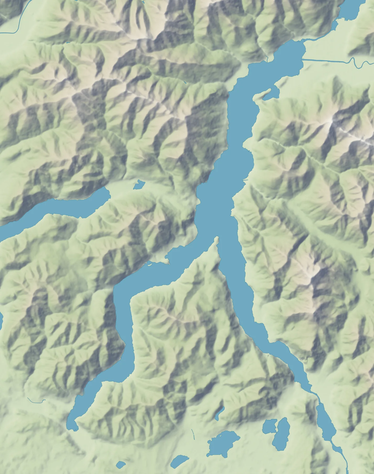
On Lake Como the sun disappears behind the mountains before astronomical sunset, at a different time in each village. The map shows the shadow now, at every hour of today and on the fifteenth of each month.
Explore the light: a table in the sun · any point · the year of light · the full moon
- Lezzeno12:33
- Brienno13:06–13:29
- Argegno13:00–13:51
- Oliveto Lario13:24–14:15
- Dongo12:38–14:26
- Musso14:56
- Cremia14:51–15:09
- Magreglio14:50–15:16
The hour on the right is when the ridge takes the sun from the village, that day. Where its streets lose it more than a quarter of an hour apart, there are two: when the shadow enters the first streets and when it has nearly all of them, nine in ten. A half-filled dot means it is happening.
The trails in the sun
The site's walks and rides, stretch by stretch: ochre where the sun reaches at that minute, blue where a mountain takes it, worked out on the same grid as the shadow, a hundred metres a cell, at the trail's own height. For the trails only the mountains count, not the trees: in a wood there is shade anyway.
A table in the sun
Bars, cafés, restaurants and ice-cream shops near the shore with outdoor seating. Today's times estimate the first and last sun at the marked point, shown as a small dot on the relief. Clouds, buildings, trees and awnings can change the tables' exposure.
First sun: bars and cafés
- Lakefrontcafé · San Siro07:37
- Lakefrontcafé · Abbadia Lariana07:40
- Lakefrontcafé · Tremezzina07:47
- Via Armando Diazbar · Menaggio07:48
- Piazza Fabio Filzibar · Tremezzina07:53
- Via Dionigi da Parravicinobar · Como07:55
Last sun
- Piazza Giuseppe Mazzinicafé · Bellagio16:45
- Lakefrontrestaurant · Varenna16:45
- Salita Serbellonirestaurant · Bellagio16:45
- Salita Mellarestaurant · Bellagio16:45
- Viale Giovanni Polvanicafé · Varenna16:43
- Piazza San Giorgiocafé · Varenna16:42
All 66 terraces, village by village
Abbadia Lariana
- Lakefrontcafé · Abbadia Lariana07:40–15:52
Bellagio
- Piazza Giuseppe Mazzinicafé · Bellagio08:16–16:45
- Salita Serbellonirestaurant · Bellagio08:39–16:45
- Salita Mellarestaurant · Bellagio08:31–16:45
Bellano
- Via XX Settembrecafé · Bellano11:14–16:19
- Piazza San Giorgiocafé · Bellano08:49–16:19
- Piazza Santa Martarestaurant · Bellano08:28–16:18
- Via Vittorio Venetocafé · Bellano08:33–16:17
- Via Carlo Albertorestaurant · Bellano09:15–16:15
Cernobbio
- Piazza Romarestaurant · Cernobbio09:02–16:37
- Piazza Risorgimentobar · Cernobbio09:03–16:35
- Piazza Belinzaghicafé · Cernobbio08:50–16:30
- Via per Cernobbiorestaurant · Cernobbio08:39–15:23
Colico
- Piazza Giuseppe Garibaldirestaurant · Colico09:50–16:19
- Viale Padaniarestaurant · Colico09:54–16:19
- Via Montecchio Nordrestaurant · Colico08:42–16:18
- Via Lungolario Polticafé · Colico09:45–16:17
- Via Palazzocafé · Colico09:52–16:15
Como
- Piazza Alcide de Gasperirestaurant · Como07:57–16:29
- Viale Genobar · Como08:34–16:20
- Via Dionigi da Parravicinobar · Como07:55–16:10
- Piazza Domenico Croggirestaurant · Como07:52–15:51
- Lungo Lario Triesterestaurant · Como07:51–15:51
- Piazza Giacomo Matteottirestaurant · Como07:53–15:50
- Lungo Lario Trentorestaurant · Como07:28–15:28
- Piazza Alessandro Voltarestaurant · Como07:26–15:19
Cremia
- Traversa Antica Canonicabar · Cremia08:30–15:15
- Via Romacafé · Cremia08:29–15:12
Dervio
- Via alla Darsenarestaurant · Dervio08:56–16:25
- Lungolago degli Ulivicafé · Dervio08:49–16:24
- Via Guglielmo Marconicafé · Dervio09:01–16:22
- Via Enrico Fermirestaurant · Dervio08:46–16:18
Domaso
- Lakefrontcafé · Domaso08:22–15:59
Dongo
- Via Vigna del Lagocafé · Dongo08:32–15:16
- Via dell'Arcocafé · Dongo08:17–13:26
Gravedona ed Uniti
- Via Sabbatirestaurant · Gravedona ed Uniti08:27–15:44
Griante
- Lakefrontcafé · Griante07:56–16:26
Lecco
- Via Romacafé · Lecco08:20–16:37
- Via Francesco Nullorestaurant · Lecco08:15–16:36
- Piazza XX Settembrecafé · Lecco08:19–16:34
- Piazza Mario Cermenaticafé · Lecco08:16–16:31
- Riva Martiri delle Foibebar · Lecco08:17–16:30
Lierna
- Via Romarestaurant · Lierna08:56–15:56
- Via Imbarcaderoice-cream shop · Lierna08:54–15:56
Malgrate
- Piazza Giuseppe Garibaldirestaurant · Malgrate07:55–15:11
Mandello del Lario
- Lakefrontrestaurant · Mandello del Lario08:39–16:00
- Piazza Romacafé · Mandello del Lario08:09–15:32
- Piazza XXV Aprilecafé · Mandello del Lario08:10–15:30
Menaggio
- Via Benedetto Castellirestaurant · Menaggio08:07–15:09
- Piazza Giuseppe Garibaldicafé · Menaggio08:05–14:49
- Via Comorestaurant · Menaggio08:05–14:40
- Via Armando Diazbar · Menaggio07:48–14:15
- Via IV Novembrecafé · Menaggio08:06–13:59
Sala Comacina
- Via Delmatirestaurant · Sala Comacina08:42–16:34
San Siro
- Antica Strada Reginarestaurant · San Siro08:17–16:05
- Lakefrontcafé · San Siro07:37–15:37
Tremezzina
- Lakefrontcafé · Tremezzina07:47–16:38
- Piazza Fabio Filzibar · Tremezzina07:53–16:38
- Via Giuseppe Mazzinipub · Tremezzina07:53–15:56
Varenna
- Lakefrontrestaurant · Varenna09:07–16:45
- Viale Giovanni Polvanicafé · Varenna09:34–16:43
- Piazza San Giorgiocafé · Varenna09:07–16:42
- Contrada dell'Arcocafé · Varenna09:07–16:41
- Contrada Scoscesacafé · Varenna09:07–16:41
- Piazzale Martiri della Libertàcafé · Varenna09:28–16:40
- Piazza della Stazionecafé · Varenna08:41–16:40
Where the list comes from
Sources and credits
The sun at any point
Choose a point on the map to estimate when the sun appears above the mountains and disappears behind the ridges. The result applies to that point: exposure can change even over a short distance.
Loading the map…
Points with outdoor seating: tap one to estimate when the sun clears the hills.
Tap the map wherever you like: a hotel, a beach, the table of a bar, a holiday flat. Or ask for your position, or paste coordinates from any map.
The year of light
Each village's hours of direct sun on the fifteenth of every month, calculated with the mountains on its horizon taken into account. Exposure varies between villages and with the seasons, especially in winter.
| Village | Jan | Feb | Mar | Apr | May | Jun | Jul | Aug | Sept | Oct | Nov | Dec |
|---|---|---|---|---|---|---|---|---|---|---|---|---|
| Brunate | 8 h 42 | 9 h 51 | 11 h 01 | 12 h 15 | 13 h 31 | 14 h 05 | 13 h 48 | 12 h 51 | 11 h 32 | 10 h 17 | 9 h 08 | 8 h 20 |
| Lecco | 7 h 43 | 8 h 29 | 9 h 31 | 10 h 59 | 11 h 58 | 12 h 29 | 12 h 15 | 11 h 23 | 10 h 19 | 8 h 47 | 7 h 56 | 7 h 24 |
| Sormano | 7 h 36 | 9 h 02 | 10 h 20 | 11 h 40 | 12 h 46 | 13 h 11 | 13 h 02 | 12 h 10 | 10 h 50 | 9 h 25 | 8 h 07 | 7 h 21 |
| Tremezzina | 7 h 54 | 9 h 09 | 10 h 08 | 11 h 38 | 12 h 25 | 12 h 57 | 12 h 43 | 12 h 01 | 10 h 52 | 9 h 31 | 8 h 24 | 7 h 15 |
| Malgrate | 7 h 29 | 8 h 26 | 9 h 26 | 10 h 58 | 12 h 00 | 12 h 50 | 12 h 26 | 11 h 23 | 10 h 16 | 8 h 55 | 7 h 50 | 7 h 05 |
| Bellagio | 7 h 24 | 8 h 29 | 9 h 27 | 10 h 30 | 11 h 13 | 11 h 46 | 11 h 34 | 10 h 47 | 9 h 57 | 8 h 54 | 7 h 46 | 6 h 56 |
| Sorico | 7 h 11 | 9 h 04 | 10 h 21 | 11 h 05 | 12 h 03 | 12 h 23 | 12 h 14 | 11 h 32 | 10 h 38 | 9 h 47 | 7 h 50 | 6 h 46 |
| Gera Lario | 7 h 08 | 9 h 03 | 10 h 19 | 10 h 58 | 12 h 07 | 12 h 33 | 12 h 19 | 11 h 26 | 10 h 37 | 9 h 47 | 7 h 37 | 6 h 45 |
| Carate Urio | 7 h 12 | 8 h 28 | 9 h 23 | 10 h 07 | 10 h 50 | 11 h 10 | 11 h 04 | 10 h 19 | 9 h 48 | 8 h 47 | 7 h 41 | 6 h 45 |
| San Siro | 6 h 54 | 7 h 51 | 9 h 00 | 10 h 15 | 11 h 05 | 11 h 41 | 11 h 31 | 10 h 46 | 9 h 29 | 8 h 28 | 7 h 06 | 6 h 44 |
| Abbadia Lariana | 7 h 20 | 8 h 08 | 8 h 59 | 10 h 56 | 12 h 09 | 13 h 11 | 12 h 46 | 11 h 28 | 9 h 40 | 8 h 25 | 7 h 36 | 6 h 37 |
| Griante | 6 h 57 | 8 h 09 | 9 h 38 | 11 h 00 | 11 h 55 | 12 h 45 | 12 h 24 | 11 h 19 | 10 h 14 | 8 h 37 | 7 h 13 | 6 h 29 |
| Como | 7 h 01 | 8 h 25 | 10 h 16 | 11 h 28 | 12 h 28 | 13 h 22 | 13 h 08 | 11 h 50 | 10 h 50 | 8 h 57 | 7 h 29 | 6 h 26 |
| Lanzo d'Intelvi | 7 h 21 | 8 h 58 | 10 h 04 | 11 h 23 | 12 h 37 | 13 h 03 | 12 h 51 | 11 h 52 | 10 h 38 | 9 h 23 | 7 h 58 | 6 h 25 |
| Sala Comacina | 6 h 52 | 8 h 13 | 9 h 23 | 10 h 43 | 11 h 39 | 12 h 01 | 11 h 54 | 11 h 09 | 9 h 51 | 8 h 33 | 7 h 27 | 6 h 18 |
| Mandello del Lario | 6 h 36 | 7 h 51 | 9 h 05 | 10 h 30 | 11 h 51 | 12 h 33 | 12 h 16 | 11 h 01 | 9 h 44 | 8 h 32 | 7 h 03 | 6 h 17 |
| Varenna | 6 h 38 | 7 h 53 | 8 h 50 | 11 h 09 | 11 h 48 | 12 h 08 | 12 h 01 | 11 h 25 | 9 h 30 | 8 h 26 | 7 h 05 | 6 h 11 |
| Cernobbio | 6 h 33 | 8 h 05 | 9 h 33 | 10 h 59 | 12 h 48 | 13 h 18 | 13 h 09 | 12 h 06 | 10 h 12 | 8 h 41 | 7 h 09 | 6 h 01 |
| Domaso | 6 h 15 | 8 h 27 | 10 h 41 | 11 h 51 | 12 h 35 | 12 h 56 | 12 h 49 | 12 h 09 | 11 h 19 | 9 h 24 | 6 h 39 | 5 h 59 |
| Gravedona ed Uniti | 6 h 23 | 7 h 46 | 10 h 24 | 11 h 27 | 12 h 45 | 13 h 25 | 13 h 14 | 11 h 47 | 11 h 10 | 9 h 10 | 6 h 41 | 5 h 57 |
| Laglio | 6 h 19 | 7 h 26 | 8 h 09 | 8 h 59 | 9 h 53 | 10 h 11 | 10 h 02 | 9 h 27 | 8 h 26 | 7 h 48 | 6 h 42 | 5 h 55 |
| Dervio | 6 h 20 | 7 h 31 | 8 h 35 | 10 h 54 | 11 h 48 | 12 h 13 | 12 h 02 | 11 h 10 | 9 h 25 | 7 h 48 | 6 h 43 | 5 h 53 |
| Valmadrera | 6 h 19 | 7 h 20 | 9 h 31 | 10 h 31 | 12 h 03 | 13 h 02 | 12 h 33 | 11 h 07 | 9 h 53 | 7 h 59 | 6 h 47 | 5 h 53 |
| Lierna | 6 h 10 | 7 h 17 | 8 h 57 | 10 h 30 | 11 h 34 | 11 h 57 | 11 h 49 | 11 h 05 | 9 h 38 | 8 h 05 | 6 h 37 | 5 h 50 |
| Magreglio | 6 h 07 | 7 h 38 | 9 h 03 | 11 h 02 | 12 h 11 | 12 h 45 | 12 h 36 | 11 h 36 | 9 h 43 | 8 h 15 | 6 h 30 | 5 h 38 |
| Cremia | 5 h 55 | 7 h 13 | 9 h 03 | 10 h 01 | 11 h 44 | 12 h 35 | 12 h 20 | 10 h 43 | 9 h 32 | 8 h 03 | 6 h 18 | 5 h 38 |
| Pognana Lario | 6 h 01 | 6 h 54 | 7 h 48 | 8 h 38 | 9 h 27 | 10 h 02 | 9 h 38 | 8 h 59 | 8 h 10 | 7 h 12 | 6 h 23 | 5 h 35 |
| Musso | 5 h 53 | 7 h 07 | 8 h 26 | 11 h 00 | 11 h 40 | 12 h 12 | 11 h 58 | 11 h 23 | 9 h 23 | 7 h 31 | 6 h 27 | 5 h 24 |
| Bellano | 6 h 29 | 7 h 52 | 9 h 25 | 10 h 23 | 11 h 14 | 11 h 55 | 11 h 45 | 10 h 40 | 9 h 53 | 8 h 29 | 7 h 26 | 5 h 15 |
| Menaggio | 5 h 27 | 7 h 13 | 8 h 47 | 11 h 35 | 12 h 37 | 13 h 19 | 12 h 55 | 12 h 03 | 9 h 49 | 8 h 19 | 5 h 54 | 5 h 12 |
| Pianello del Lario | 5 h 32 | 7 h 32 | 8 h 42 | 9 h 55 | 11 h 45 | 12 h 21 | 12 h 04 | 10 h 50 | 8 h 59 | 8 h 02 | 5 h 59 | 5 h 08 |
| Esino Lario | 5 h 45 | 8 h 11 | 9 h 54 | 11 h 52 | 12 h 53 | 13 h 20 | 13 h 10 | 12 h 20 | 10 h 48 | 8 h 49 | 6 h 12 | 4 h 59 |
| Colonno | 5 h 09 | 8 h 33 | 9 h 34 | 10 h 54 | 11 h 53 | 12 h 22 | 12 h 12 | 11 h 22 | 10 h 02 | 9 h 00 | 7 h 18 | 4 h 53 |
| Faggeto Lario | 5 h 58 | 8 h 14 | 9 h 52 | 11 h 17 | 12 h 37 | 13 h 17 | 12 h 56 | 11 h 50 | 10 h 20 | 8 h 58 | 6 h 47 | 4 h 50 |
| Colico | 5 h 39 | 7 h 24 | 10 h 07 | 12 h 27 | 13 h 17 | 13 h 50 | 13 h 36 | 12 h 49 | 11 h 34 | 8 h 35 | 5 h 58 | 4 h 47 |
| Argegno | 4 h 35 | 5 h 23 | 9 h 50 | 11 h 39 | 12 h 43 | 13 h 18 | 13 h 03 | 12 h 21 | 10 h 38 | 5 h 58 | 4 h 46 | 4 h 24 |
| Oliveto Lario | 4 h 41 | 6 h 20 | 8 h 15 | 9 h 43 | 10 h 28 | 11 h 03 | 10 h 47 | 10 h 05 | 8 h 56 | 7 h 16 | 5 h 12 | 4 h 23 |
| Moltrasio | 4 h 41 | 6 h 50 | 8 h 49 | 9 h 56 | 10 h 46 | 11 h 23 | 11 h 10 | 10 h 14 | 9 h 21 | 7 h 47 | 5 h 35 | 4 h 22 |
| Nesso | 5 h 23 | 7 h 14 | 8 h 44 | 9 h 47 | 10 h 58 | 11 h 23 | 11 h 11 | 10 h 16 | 9 h 13 | 7 h 37 | 6 h 35 | 4 h 20 |
| Dorio | 4 h 38 | 5 h 51 | 7 h 26 | 9 h 02 | 10 h 45 | 11 h 35 | 11 h 17 | 9 h 46 | 8 h 10 | 6 h 30 | 4 h 58 | 4 h 11 |
| Torno | 4 h 23 | 6 h 13 | 9 h 31 | 11 h 06 | 12 h 01 | 12 h 40 | 12 h 24 | 11 h 36 | 10 h 35 | 6 h 44 | 4 h 52 | 3 h 59 |
| Dongo | 4 h 05 | 5 h 31 | 7 h 20 | 9 h 43 | 10 h 33 | 11 h 39 | 11 h 11 | 10 h 02 | 8 h 31 | 6 h 11 | 4 h 35 | 3 h 47 |
| Brienno | 3 h 49 | 5 h 20 | 7 h 39 | 8 h 55 | 9 h 36 | 9 h 59 | 9 h 48 | 9 h 13 | 8 h 17 | 6 h 08 | 4 h 14 | 3 h 30 |
| Blevio | 3 h 15 | 6 h 27 | 8 h 31 | 10 h 07 | 10 h 37 | 11 h 08 | 10 h 55 | 10 h 19 | 9 h 20 | 7 h 31 | 4 h 55 | 2 h 44 |
| Lezzeno | 0 h 00 | 6 h 51 | 9 h 19 | 11 h 21 | 12 h 11 | 13 h 29 | 12 h 45 | 11 h 37 | 9 h 56 | 8 h 03 | 0 h 00 | 0 h 00 |
The night
The full moon over the ridge
The next full moon is Tuesday 24 November, full at 16:00. For a reference point, assuming a flat horizon, moonrise is estimated at 16:10. With the mountains included, it is estimated in Lanzo d'Intelvi at 16:31 and in Pognana Lario at 20:13.
Times are estimated from the moon's position and the horizon at the reference points. Two times describe variation between nearby sampled points, without measuring every street. Clouds are excluded from the calculation.
- Lanzo d'Intelvi16:313D — watch the moon rise from Lanzo d'Intelvi
- Argegno16:443D — watch the moon rise from Argegno
- Colonno16:45–17:103D — watch the moon rise from Colonno
- Sala Comacina16:483D — watch the moon rise from Sala Comacina
- Cremia16:483D — watch the moon rise from Cremia
- Sormano16:50–18:243D — watch the moon rise from Sormano
- Pianello del Lario16:513D — watch the moon rise from Pianello del Lario
- Musso16:553D — watch the moon rise from Musso
- Tremezzina16:56–18:233D — watch the moon rise from Tremezzina
- Valmadrera16:563D — watch the moon rise from Valmadrera
- Dongo16:573D — watch the moon rise from Dongo
- Lezzeno16:57–17:493D — watch the moon rise from Lezzeno
All 45 villages
- Malgrate16:59–17:193D — watch the moon rise from Malgrate
- Magreglio17:003D — watch the moon rise from Magreglio
- Griante17:013D — watch the moon rise from Griante
- Cernobbio17:043D — watch the moon rise from Cernobbio
- Gravedona ed Uniti17:05–17:383D — watch the moon rise from Gravedona ed Uniti
- Menaggio17:083D — watch the moon rise from Menaggio
- Domaso17:093D — watch the moon rise from Domaso
- Moltrasio17:09–17:393D — watch the moon rise from Moltrasio
- San Siro17:16–17:323D — watch the moon rise from San Siro
- Colico17:213D — watch the moon rise from Colico
- Gera Lario17:22–17:523D — watch the moon rise from Gera Lario
- Bellagio17:29–19:373D — watch the moon rise from Bellagio
- Lecco17:31–17:483D — watch the moon rise from Lecco
- Sorico17:35–18:133D — watch the moon rise from Sorico
- Torno17:363D — watch the moon rise from Torno
- Carate Urio17:40–17:593D — watch the moon rise from Carate Urio
- Brunate17:42–18:573D — watch the moon rise from Brunate
- Oliveto Lario17:473D — watch the moon rise from Oliveto Lario
- Faggeto Lario17:59–18:433D — watch the moon rise from Faggeto Lario
- Abbadia Lariana18:00–18:203D — watch the moon rise from Abbadia Lariana
- Mandello del Lario18:00–18:473D — watch the moon rise from Mandello del Lario
- Dervio18:03–18:193D — watch the moon rise from Dervio
- Brienno18:043D — watch the moon rise from Brienno
- Como18:04–18:343D — watch the moon rise from Como
- Esino Lario18:05–18:313D — watch the moon rise from Esino Lario
- Laglio18:11–18:263D — watch the moon rise from Laglio
- Bellano18:35–19:033D — watch the moon rise from Bellano
- Nesso18:48–19:553D — watch the moon rise from Nesso
- Varenna18:55–20:213D — watch the moon rise from Varenna
- Lierna19:06–19:303D — watch the moon rise from Lierna
- Dorio19:17–19:393D — watch the moon rise from Dorio
- Blevio19:28–19:593D — watch the moon rise from Blevio
- Pognana Lario19:28–20:193D — watch the moon rise from Pognana Lario
How it is worked out
The calculation estimates when the sun clears the ridges around the chosen point. It accounts for terrain and woodland, but excludes shade from buildings and clouds.
The method, step by step
The relief shows the shape of the ground. Ridges and valleys help identify the slopes that can hide the sun.
For the chosen date and minute, the model compares the sun's position with the terrain. Shaded areas are those where the terrain blocks sunlight.
Each village's times are calculated from a reference point and the outline of the surrounding mountains. These are local estimates, separate from the simplified shadow shown on the map.
The estimated time can vary within one village: today at Dongo the estimated interval runs from 12:38 to 14:26. The model compares points sampled every fifty metres within three hundred metres of the village reference point. Where two times are shown, the interval describes variation between sampled points; it does not measure every street or building.
Around the lake, the calculation uses Lombardy's terrain model and woodland map. Woods are assigned a standard height; vegetation in an individual garden may differ.
A nearby slope can change the estimated time even between points close together. To check a stretch of lakefront or a square, choose the point on the map.
The times also depend on the direction of the sun. A point may remain in shade in the morning and receive sunlight in the afternoon, or the other way round.
The sun's path changes with the seasons. Choose the date of your visit to compare morning and afternoon sunlight.
Clouds can hide the sun even where the model indicates sunlight. Check the weather forecast too for conditions on the day.
Where nearby mountains leave the horizon open, the calculation also includes distant peaks, up to two hundred kilometres away. Their presence in the model does not guarantee that they will be visible through the day's haze.
For a point chosen on the map, the horizon is calculated from about two metres above the ground. A raised terrace or balcony may have a different horizon.
In the 3D model, heights are exaggerated to make the terrain easier to read. Choosing a village restores the true vertical scale, with a view from about twenty metres above the ground. The sun and moon are shown in calculated positions. Water beyond the relief uses OpenStreetMap data through OpenFreeMap.